Some posts on this site contain affiliate links. If you book or buy something through these links, I earn a small commission (at no extra cost to you). Take a look at my privacy policy for more information.
This 4-mile circular walk around Portland Bill is a lovely coastal walk which takes in some of the key features of the area.
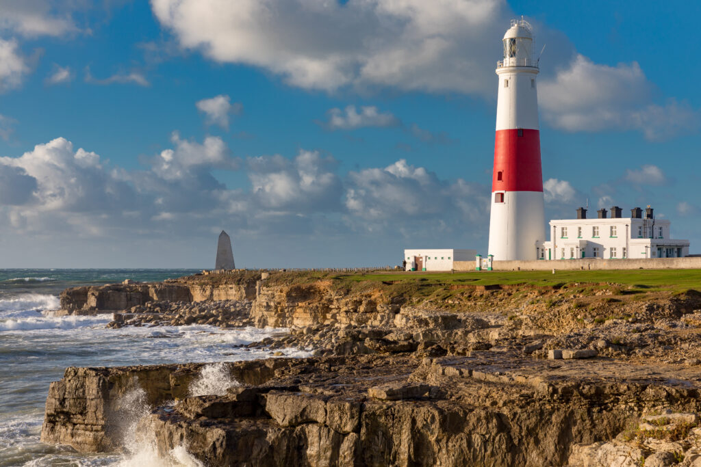
Portland Bill is the southernmost tip of the Isle of Portland, known for its iconic red and white lighthouse and monstrous waves. Built in 1906 (replacing two older lighthouses which still stand nearby), the lighthouse still works today, guiding ships safely through the hazardous waters around Portland Bill.
These waters, where two tides meet to create fierce currents, are responsible for the dramatic landscapes around Portland Bill. Waves crash against the low cliffs almost continuously: on windy days, the display is particularly impressive. The resulting coastal erosion has created a series of rock stacks, sea caves, rocky ledges, and blow-holes.
Wild, windswept, and ruggedly scenic, Portland Bill is the perfect spot for a clifftop ramble. Use our walking guide and map to explore…
Portland Bill Walk: Details and Map
- Distance: 3.9 miles / 6.2km
- Time: Around 2 hours
- Elevation Gain: 259 ft
- Difficulty: Easy
- Accessibility: Some uneven ground but should be suitable for an all-terrain mobility scooter. One kissing gate (avoidable via a longer detour). No stairs.
- Terrain: Gravel & dirt paths (somewhat uneven), grass. Rocky in places. Inland paths and farm tracks may be muddy after wet weather.
- Parking: Pay and display parking at Portland Bill Car Park.
- Facilities: Free public toilets and a restaurant at Portland Bill Car Park.

To make following this walk easier, feel free to use my GPS trail route on Wikiloc. It’s a free app where people can share hiking routes! You’ll probably still find my instructions below helpful, though.
Portland Bill 4 Mile Circular Walk Route
This route takes you right around the Bill, past both the older lighthouses and through some of Portland’s historic coastal quarries.
At one time, quarrying was the biggest industry on the Isle of Portland. The local limestone was famed for its versatility and creamy colour. Portland Stone was even used to build St. Paul’s Cathedral and Buckingham Palace! The cliffs around Portland Bill are still strewn with cut rocks and old quarrying machinery (including clifftop cranes, called derricks).

Step 1 – Portland Bill to the Coastguard Station
Starting Point: Portland Bill Car Park (click here for the Google Maps location)
Starting in Portland Bill Car Park with your back to the lighthouse, walk up through the car park and out at the top via a grassy path. Cross over the driveway leading into the Ministry of Defence (MOD) Magnetic Range (the area surrounded by the tall perimeter fence) and keep following the grass path with the MOD fence on your left. Where the perimeter fence ends, you will pick up the Coast Path which closely follows the cliff edge, sloping gently uphill.
At the top of the hill, you will pass the National Coastwatch Coastguard Station; pause here for a splendid view of Portland Bill Lighthouse behind you. Behind the coastguard station is Old Higher Lighthouse, one of Portland’s original lighthouses, built in the 18th century. It ceased operation in 1906 when the newer lighthouse was built, and was later home to palaeobotanist Dr Marie Stopes, a pioneer of birth control.

The coast path continues beyond the lighthouse with fenced paddocks on the right and the rather ugly buildings of Southwell Business Park up ahead.
Step 2 – Cutting across farmland

Shortly before reaching the Business Park, a path branches off to the right. There’s no marker, but look out for a large block of stone to the left of the coast path (see photo above). Take the turning and follow the path alongside a low drystone wall.
After around 130m, this path curves around to the right and heads gently downhill between more fields, then reaches a junction where the right-hand path leads back across the fields to the coast path you just left behind. Turn left instead and head slightly uphill, then take the left-hand fork to follow the path with the business park directly on your left across the fields.

At the end of this path, you will come to a junction with a dry stone wall and a metal gate ahead of you (photo above). Turn left here and follow the winding path all the way to the end, passing the farmhouses and barns at Sweethill Farm.
Step 3 – Back to the Coast Path

Shortly before the farm track reaches Sweet Hill Road, you’ll see a kissing gate on the right-hand side next to a wide metal gate (photo above). Head through this and take the narrow dirt path heading towards the sea. After clearing the first hedgerow, you will have a fantastic view on the left of the village of Southwell, with the cliffs of the Jurassic Coast in the distance beyond.
Keep straight on this path until you come to Portland Bill Road. Turn left and follow the road a short way (around 175m). Just before the road reaches Southwell, cross over to take the footpath on the right (photo below). Follow this path downhill, with an abandoned quarry on your right, to meet the Coast Path.

Optional Detour: Turn left initially to detour northeast along the Coast Path for a look at the old quarry workings. Before the path meets back up with the main road, turn around and go back the way you came to carry on along the Coast Path heading south.

Step 4 – Coast path to Portland Bill
If you skipped the above detour, turn right to follow the Coast Path south towards Portland Bill. From here, the route is relatively straightforward: keep following the Coast Path forward. Keep to the path around here as there are a lot of loose rocks and dangerous cliff edges. Enjoy the views along the Jurassic coast behind you. On a clear day, it’s possible to see St Aldhelms Head on the Isle of Purbeck.
There are a few sights to look out for as you follow this stretch of the Coast Path:
Quarries: You’ll see evidence of Portland’s former quarrying industry everywhere. Look for stark stone walls, square-shaped cut boulders, rusted metal fixings, and leftover sections of construction.
Derrick Crane: Shortly after the point where the path dips down and back up again, you’ll reach a wood and metal structure on the edge of the cliff. This is one of the old derrick cranes leftover from the quarrying industry, once used to lower stone blocks directly onto waiting ships below.

Sea Cave & Blow Hole: Just beyond the derrick, the path crosses a small stream via a wooden footbridge at Mitchell Meadows. Just after this is a dip on the left, where a sea cave has partly collapsed to form a blow hole. It’s covered by an iron grate for safety, but you can look down to see the waves churning in the cave below.

Rock Pool: Shortly after passing two wooden huts (the first of many) on the left, you can spot a large natural pool in the rocks below (depending on tide height).

Beach huts: The coast path continues through a large collection of timber huts – some painted in bright colours. These were originally built as fisherman’s sheds but are now used as beach huts and day retreats.

Old Lower Lighthouse: The second of the original lighthouses, built in 1869 to work alongside the Higher Lighthouse. The white tower stands just behind the beach huts.
Waves and rock stacks: All the cliffs and sea caves along this stretch are excellent spots for watching the waves crash, particularly on windy days. This area is known for the treacherous “Portland Race”, caused by the meeting of the tides between the Bill and a nearby sandbank: the strong currents cause a continuous display of huge waves (hence the presence of the lighthouse). There’s also another derrick near the end of the beach huts.
Step 5 – Portland Bill

Finally, the path reaches Portland Bill Lighthouse again. Before heading back into the carpark, follow the path around the tip of Portland Bill. A large stone obelisk stands at the very tip. It was built in 1844 to warn ships of a low rock shelf which extends 30m into the sea. Portland Bill Lighthouse was added in 1906 to replace the older Higher and Lower Lighthouses.
Slightly further around, you can see Pulpit Rock: a large rock stack. It was created when a natural rock arch was removed by quarrying during the 19th century. The rock is said to resemble an open bible leaning on a pulpit, hence the name.

From here, you can cut back into the car park to end your walk. If you have time, take a trip to the Lighthouse Visitor Centre. You can even take a tour to climb the lighthouse tower. There’s also a coffee shop at the Lighthouse and the Lobster Pot restaurant if you’re in need of refreshment.
Read More
15 Short Dorset Coast Walks Under 4 Miles
Lulworth Cove to Durdle Door Walk
If you enjoyed this short circular walk around Portland Bill, or have any feedback for us, please leave a comment below! Especially if any info needs updating.